Catches
earthquakes SS.OAKM1.00.EHZ has recorded, confirmed by the USGS catalog
These are the earthquakes the station has recorded and that the USGS catalog confirms — magnitude, location, depth and origin time are the catalog’s; the waveform, the peak and the timing are ours. A single geophone detects; a network confirms, and every event here was also recorded by professional stations, which is what makes it an earthquake and not a truck.
Each image is the raw 1–15 Hz trace with its smoothed envelope, and a spectrogram below it: an earthquake arrives as a burst that starts at low frequency and stays there, because the ground filters out the high frequencies on the way; a local disturbance is broadband and impulsive. That difference is how the detector tells them apart — with one exception that proves it: a quake a few kilometres away arrives broadband too, because there is barely any path to do the filtering.
Listening to quakes
The frequencies of earthquakes are usually well below the limits of human hearing, but we are able to shift them up into an audible range. Why would you want to “hear” them? Because it gives you a sense of the character and duration of how an earthquake is felt. When you experience one, live, it usually takes you several seconds to recognize what is happening, and your mind is racing through questions of how to react. You aren’t trying to analyze the changing intensity and frequency of the event.
You can see that in our spectrum charts, but that’s still not intuitive. But if you listen to the quake — remapped into the range we can hear — suddenly you can tell how long it lasts, how the intensity hits fast and then how quickly, or not, it subsides. You can even sense how fast or slow the shaking is. It’s not quantitative, it’s qualitative, but it is the closest thing you’ll feel to the real thing short of being in an earthquake. Only with the sound you’re not worrying the house will collapse on you.
From 5,409 km away
The furthest thing this station has recorded is not in the table below. On 9 October 2026 an M7.7 off Panama, 5,409 km away, sent a P wave through the Earth’s mantle, and 8 minutes 44 seconds later it reached the garage. It is a different kind of catch from everything here: a faint rise below 2 Hz that a statistical test separates from the background, not a burst you can see in the 1–15 Hz band. So it is kept out of this page’s numbers and written up on the Range page.
M3.3 · 3 km ESE of Larkfield-Wikiup, CA
2026-09-03 17:33:27 UTC · 13.3 km · the largest voltage this station has ever produced
the trace, the sound and the story
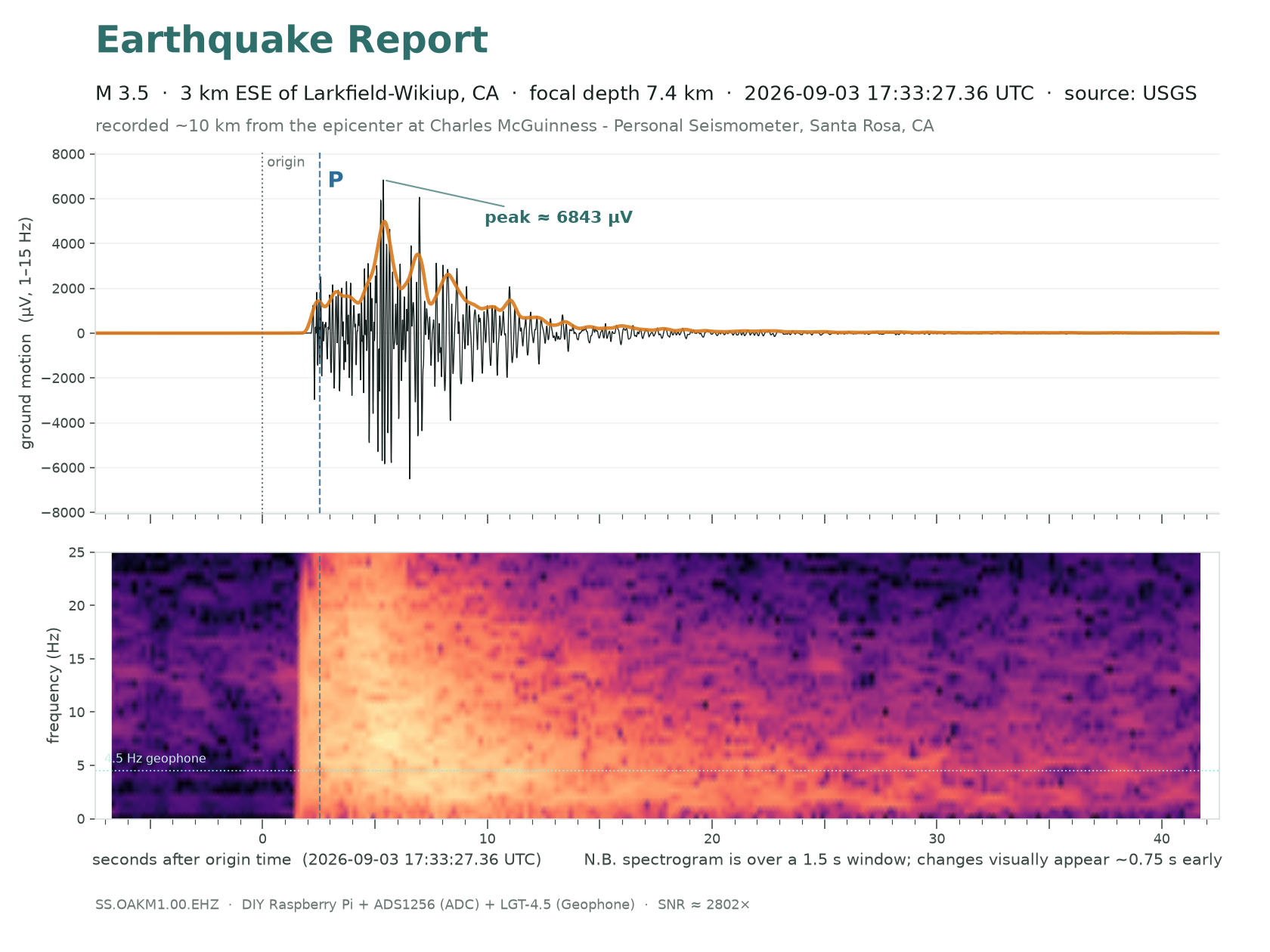
Listen for how the pitch balance changes at the P wave (marked where it was picked), at the S wave (the dashed mark is its predicted arrival) and through the coda that follows. Volume is normalised to this clip, so it only says how much energy there is before, during and after the event relative to its own peak — not how big the earthquake was.
- Five times anything before it. The peak in the 1–15 Hz band was 6,843 µV against the M4.2 Cloverdale’s 1,406, and the ADC still had sevenfold headroom: at gain 64 it clips near 39,000 µV. In ground terms, NP.1835 read a peak of 1.5 mm/s in the 5–15 Hz band, this station 0.84 mm/s.
- The closest sizeable earthquake in the record, 13.3 km hypocentral at bearing 304°, under the Rodgers Creek fault — the fault system this station was sited to listen to. Nothing else at M2.5 or above has landed within 35 km, so at this magnitude it is nearest by a factor of three; four smaller catches are closer still. P broke out of the noise at +2.2 s after origin against a predicted +2.6; S was due at about +4.4. With so little path there is almost no room for the two to separate.
M4.7 · 85 km W of Petrolia, CA
2026-08-29 02:41:11 UTC · 318.6 km · the largest magnitude in the record
the trace, the sound and the story
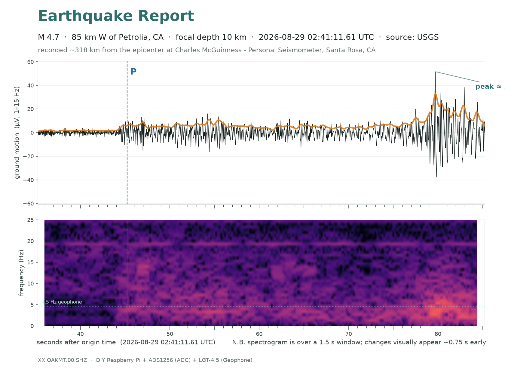
Listen for how the pitch balance changes at the P wave (marked where it was picked), at the S wave (the dashed mark is its predicted arrival) and through the coda that follows. Volume is normalised to this clip, so it only says how much energy there is before, during and after the event relative to its own peak — not how big the earthquake was.
- The furthest catch by a factor of 3.6 — 319 km against a previous record of 89 km. Peak 52 µV, signal-to-noise ~27×, and energy above twice the noise floor for five minutes.
- Identified by the clock, not by amplitude. Pn was due at 02:41:56.7 (iasp91, 319 km, 10 km deep) and the detector triggered at 02:41:57.0; Sn was due at 02:42:32.1 and the envelope peaked at 02:42:31.7. Two independent arrivals, each inside half a second. It is also the only catalogued event within 700 km in a nine-minute window.
M4.4 · 184 km W of Ferndale, California
2026-08-31 08:36:48 UTC · 402.1 km · the greatest distance, fitted or not
more
Holds a record and has not been written up yet — the rule found it, not a person. its measurements →
M3.8 · 20 km WSW of Gerlach, Nevada
2026-09-16 07:17:25 UTC · 354.0 km · where measurement ends and extrapolation begins
more
Holds a record and has not been written up yet — the rule found it, not a person. its measurements →
M2.7 · 3 km ESE of Santa Rosa, CA
2026-09-16 01:40:30 UTC · 10.5 km · the nearest event large enough to be unmistakable
more
Holds a record and has not been written up yet — the rule found it, not a person. its measurements →
M1.9 · 4 km ESE of Santa Rosa, CA
2026-09-16 12:21:50 UTC · 9.4 km · almost no path between the source and the sensor
more
Holds a record and has not been written up yet — the rule found it, not a person. its measurements →
Every confirmed event
Every event the catalog comparison confirms, newest first — the same list the map is calibrated from, so the two cannot disagree. Nothing here needs the detector to have fired: the catalog gives the time and the archive is cut there afterwards, which is how the weak ones get in. Peak is the maximum of the 1 s-smoothed 1–15 Hz envelope in the P/S window, so it reads below the raw sample peaks quoted in the write-ups; SNR is that peak over the RMS of the minute before; P pred. is the predicted P arrival after origin. vs NP.1835 is the amplitude ratio against the USGS strong-motion station 1.64 km away, explained in the next section; 1.00 means the calibration is exact. Bold rows have a write-up below. The list starts at the 100 sps cutover of 2026-07-25, so the first catch, the M2.5 St. Helena a few hours before it, has a write-up but no row.
| UTC | M | place | trace | km | depth | peak µV | SNR | P pred. | vs NP.1835 |
|---|---|---|---|---|---|---|---|---|---|
| 2026-09-19 11:53 | 1.8 | 7 km WNW of Cobb | 46 | 1.9 | 3 | 3 | 7.8 s | 1.43× | |
| 2026-09-16 12:21 | 1.9 | 4 km ESE of Santa Rosa | 9 | 8.2 | 82 | 36 | 1.8 s | 0.81× | |
| 2026-09-16 11:36 | 1.6 | 8 km NW of The Geysers | 46 | 1.8 | 3 | 3 | 7.8 s | 0.56× | |
| 2026-09-16 07:17 | 3.8 | 20 km WSW of Gerlach, Nevada | 354 | 7.0 | 3 | 4 | 50.5 s | 1.26× | |
| 2026-09-16 02:00 | 1.6 | 4 km ESE of Santa Rosa | 10 | 8.5 | 38 | 17 | 1.8 s | 1.12× | |
| 2026-09-16 01:40 | 2.7 | 3 km ESE of Santa Rosa | 10 | 9.1 | 558 | 161 | 2.0 s | 0.87× | |
| 2026-09-14 13:47 | 3.0 | 9 km SW of Brentwood | 97 | 16.9 | 9 | 4 | 16.5 s | 1.10× | |
| 2026-09-12 19:50 | 1.8 | 6 km WNW of The Geysers | 43 | 3.0 | 9 | 3 | 7.4 s | 1.55× | |
| 2026-09-12 18:39 | 2.9 | 4 km W of Cobb | 43 | 1.1 | 67 | 24 | 7.4 s | 1.51× | |
| 2026-09-12 07:25 | 3.4 | 9 km SW of Brentwood | 98 | 17.9 | 15 | 12 | 16.5 s | 1.54× | |
| 2026-09-11 10:24 | 2.3 | 3 km ESE of The Geysers | 36 | -0.3 | 14 | 15 | 6.2 s | 1.45× | |
| 2026-09-10 23:03 | 2.5 | 1 km N of The Geysers | 39 | 0.5 | 22 | 7 | 6.8 s | 1.05× | |
| 2026-09-10 20:36 | 3.1 | 10 km WNW of Cobb | 49 | 3.9 | 66 | 18 | 8.5 s | 2.06× | |
| 2026-09-10 20:36 | 3.0 | 10 km WNW of Cobb | 48 | 5.1 | 61 | 17 | 8.3 s | 1.82× | |
| 2026-09-10 11:27 | 2.4 | 9 km WNW of The Geysers | 45 | 1.8 | 18 | 18 | 7.8 s | 1.09× | |
| 2026-09-10 02:52 | 2.5 | 2 km ESE of Oakland | 83 | 9.9 | 7 | 3 | 14.3 s | 5.68× | |
| 2026-09-09 01:08 | 2.3 | 8 km NW of The Geysers | 46 | 2.2 | 18 | 6 | 7.8 s | 1.06× | |
| 2026-09-08 09:26 | 1.8 | 3 km SE of The Geysers | 36 | 2.6 | 8 | 9 | 6.1 s | 2.06× | |
| 2026-09-08 08:19 | 0.8 | 8 km WSW of Kenwood | 10 | 5.8 | 5 | 6 | 1.8 s | 1.22× | |
| 2026-09-07 07:18 | 2.0 | 5 km WNW of Cobb | 45 | 2.0 | 7 | 9 | 7.8 s | 1.37× | |
| 2026-09-07 03:17 | 2.2 | 3 km SSW of Cobb | 40 | 1.6 | 17 | 9 | 6.9 s | 1.95× | |
| 2026-09-06 08:53 | 1.3 | 1 km WNW of Anderson Springs | 37 | 3.3 | 2 | 3 | 6.4 s | 1.34× | |
| 2026-09-05 20:07 | 1.1 | 2 km SSE of Santa Rosa | 9 | 6.7 | 10 | 4 | 1.8 s | 1.23× | |
| 2026-09-05 08:23 | 1.4 | 4 km SSE of Santa Rosa | 10 | 7.7 | 28 | 22 | 2.0 s | 0.82× | |
| 2026-09-03 17:33 | 3.3 | 3 km ESE of Larkfield-Wikiup | 13 | 8.8 | 2,668 | 462 | 2.6 s | 1.31× | |
| 2026-09-02 09:45 | 1.9 | 4 km SSE of Cloverdale | 49 | 4.0 | 4 | 5 | 8.4 s | 0.94× | |
| 2026-09-02 03:49 | 2.4 | 2 km N of Middletown | 36 | 4.7 | 32 | 16 | 6.2 s | 1.37× | |
| 2026-08-31 08:36 | 4.4 | 184 km W of Ferndale not in fit | 402 | 10.0 | 2 | 3 | 56.0 s | — | |
| 2026-08-31 07:36 | 1.1 | 3 km NNW of Larkfield-Wikiup | 17 | 5.2 | 3 | 4 | 2.9 s | 1.46× | |
| 2026-08-30 08:35 | 2.1 | 6 km NW of The Geysers | 43 | 2.6 | 7 | 6 | 7.4 s | 1.41× | |
| 2026-08-29 06:14 | 1.4 | 3 km NNW of Larkfield-Wikiup | 17 | 6.1 | 8 | 4 | 2.9 s | 1.38× | |
| 2026-08-29 04:13 | 1.2 | 7 km ESE of Santa Rosa | 9 | 8.8 | 13 | 5 | 1.8 s | 0.86× | |
| 2026-08-29 02:41 | 4.7 | 85 km W of Petrolia not in fit | 319 | 10.0 | 19 | 8 | 45.7 s | 1.08× | |
| 2026-08-29 00:42 | 1.8 | 6 km ESE of Santa Rosa | 10 | 9.8 | 78 | 25 | 2.0 s | 1.12× | |
| 2026-08-27 19:06 | 2.2 | 2 km NE of The Geysers | 39 | 1.5 | 11 | 3 | 6.7 s | 2.10× | |
| 2026-08-25 00:22 | 2.4 | 9 km WNW of The Geysers | 45 | 1.7 | 27 | 9 | 7.8 s | 1.30× | |
| 2026-08-24 12:09 | 1.7 | 5 km NNW of The Geysers | 43 | 2.3 | 4 | 4 | 7.5 s | 0.85× | |
| 2026-08-21 11:38 | 2.3 | 5 km SSW of Alameda | 89 | 16.5 | 5 | 5 | 15.2 s | 1.05× | |
| 2026-08-21 04:19 | 1.8 | 4 km ENE of Saint Helena | 20 | 8.0 | 11 | 6 | 3.4 s | 1.77× | |
| 2026-08-20 18:24 | 1.2 | 5 km NE of Kenwood | 12 | 6.5 | 19 | 5 | 2.2 s | 2.63× | |
| 2026-08-20 04:05 | 2.3 | 2 km N of The Geysers | 40 | 0.9 | 17 | 9 | 6.9 s | 1.22× | |
| 2026-08-18 06:47 | 2.0 | 3 km ESE of The Geysers | 36 | 1.5 | 8 | 7 | 6.2 s | 1.20× | |
| 2026-08-17 08:18 | 2.5 | 2 km SE of Concord | 80 | 16.1 | 5 | 6 | 13.7 s | 1.72× | |
| 2026-08-16 11:14 | 1.9 | 8 km ESE of Cloverdale | 45 | 6.4 | 4 | 5 | 7.8 s | 1.05× | |
| 2026-08-13 15:30 | 3.8 | 3 km N of San Leandro | 88 | 5.5 | 175 | 35 | 15.2 s | 1.39× | |
| 2026-08-12 10:59 | 1.6 | 6 km NW of The Geysers | 44 | 3.3 | 9 | 4 | 7.5 s | 0.22× | |
| 2026-08-12 10:30 | 3.2 | 6 km NW of The Geysers | 43 | 2.9 | 82 | 17 | 7.5 s | 1.13× | |
| 2026-08-12 10:28 | 3.2 | 6 km NW of The Geysers | 44 | 2.8 | 64 | 18 | 7.5 s | 0.89× | |
| 2026-08-12 09:06 | 1.7 | 5 km W of Glen Ellen | 10 | 0.9 | 55 | 28 | 2.0 s | 0.93× | |
| 2026-08-11 21:35 | 2.8 | 7 km NW of The Geysers | 45 | 2.5 | 47 | 4 | 7.7 s | 1.00× | |
| 2026-08-11 21:34 | 3.0 | 7 km NW of The Geysers | 45 | 2.8 | 47 | 4 | 7.7 s | 0.93× | |
| 2026-08-08 10:33 | 2.0 | 5 km E of Hidden Valley Lake | 42 | 8.5 | 35 | 8 | 7.3 s | 0.63× | |
| 2026-07-29 20:11 | 2.2 | 8 km ESE of Cloverdale | 45 | 4.5 | 15 | 4 | 7.8 s | 0.90× † | |
| 2026-07-29 11:21 | 1.3 | 12 km NNW of Angwin | 28 | 5.3 | 5 | 3 | 4.9 s | 2.25× † | |
| 2026-07-29 10:48 | 1.9 | 7 km ESE of Cloverdale | 46 | 6.8 | 5 | 4 | 7.9 s | 1.15× † | |
| 2026-07-29 03:48 | 2.2 | 8 km ESE of Cloverdale | 46 | 5.5 | 12 | 6 | 7.9 s | 1.03× † | |
| 2026-07-29 02:40 | 4.2 | 8 km ESE of Cloverdale | 46 | 5.9 | 520 | 192 | 7.9 s | 0.74× † | |
| 2026-07-27 16:13 | 3.4 | 18 km SE of Silver Springs, Nevada | 324 | 12.0 | 10 | 4 | 46.1 s | 5.40× † | |
| 2026-07-27 15:29 | 2.7 | 3 km ENE of The Geysers | 38 | 2.0 | 41 | 14 | 6.6 s | 1.09× † | |
| 2026-07-27 06:29 | 2.4 | 3 km NW of The Geysers | 41 | 3.5 | 20 | 13 | 7.1 s | 1.42× † |
† recorded with the earlier front end (before the 2026-08-07 rebuild): a different amplitude epoch from the calibration anchors, shown but not averaged.